Tuesday, December 8, 2009

SANPETE FOOTHILLS


AMY'S NOTES: This is post #101. A really cold but beautiful late afternoon walk. Smitten with the light and fresh snow. A busted knee and a sick dog makes for slow walking. Call it a meander. Hope is the only one with any agility to speak of these days and she certainly has enough for all. The first big snow of winter. Soft, powdery, Utah snow. And the warm yellow light of the desert in december. The dogs love it - it's what Bernese Mountain dogs were bred for. They are utterly in their element.

Tuesday, November 10, 2009

LITTLE WILD HORSE & BELL CANYONS LOOP, SAN RAFAEL SWELL


HIKERS: Kim, Cory, Dane, Drew, Christian, Amy, Brook
WEATHER: 60's, Sunny
RT TIME: 3.5 hours
DISTANCE: 7.5 miles

AMY'S NOTES: This is a very accessible hike in San Rafael Swell about 5 miles from Goblin Valley State Park. We started at the parking lot trailhead for Little Wild Horse and looped back through Bell Canyon. The midsection connecting the 2 canyons is a multiple use dirt road with full sun exposure. Wild Horse is a great canyon for running up and down walls - demonstrated best by Christian! More detailed info and maps on Tom Jones' website: http://www.canyoneeringusa.com/utah/swell/little.htm

Wednesday, October 28, 2009

CANYON ROAD- IN THE SNOW


HIKERS: Kim, Amy, and the dogs
TIME: 8:30 am- 9:30 am
WEATHER: 24 f, snowing

KIM'S NOTES: It was interesting to be hiking in the snow again. I had some mixed feelings about it. It was beautiful, no doubt about that, but a little too early in the weather scheme of things for us to be getting 4-8 inches of snow. Nice hike though.

Monday, October 26, 2009

ZION, CORAL PINK SAND DUNES


Walking on the petrified dunes.


The actress.


Modeling the hair piece.

AMY'S NOTES: Spent the weekend in Zion National Park shooting an experimental film short. I didn't have too much time for hiking but did manage a few solitary wanderings up side canyons in the petrified sand dune area. We also spent some time shooting in Coral Pink Sand Dune State Park which looks just as the name describes - coral pinkish, dunish, and very sandy. Beautiful weather in the 70's.

Monday, October 19, 2009

GREEN RIVER DAILY


AMY'S NOTES: A beautiful weekend on the Green. Ran from Buckley Wash to Swazey's a couple of times with bike shuttles. Forgot the tent, forgot the bike seat, forgot my paddle, lost my wallet... Slept in the tandem inflatable, borrowed a paddle, got the wallet back thanks to the honesty of strangers... it all worked out. The cottonwoods were brilliant yellow, the beaches were empty, the sun warm, and the nights cool. A handful of rafters came down from Desolation but it was otherwise empty. Sad to see summer go. Oh yeah, and I forgot the pan to cook dinner in. :-)

Friday, October 16, 2009

MAPLE CANYON EXPLORATION


HIKERS: Cory, Kim, Phoebe
TRAIL: view point, slot canyon, and pipe dream

NOTES: Maple canyon is our oasis in the desert. Who would ever guess that a fern could grow in the wild in our climate, but it is true and we saw them today. I have hiked this trail before, but we took the 'road less traveled' a couple of times and were greatly rewarded by amazing scenery. The colors are so gorgeous right now I was mentally kicking myself the whole time that I didn't have my camera. We also found a huge cavern called 'pipe dreams' that has bolts all over the ceiling for climbers. I am so disappointed there weren't any climbers on one of the routes. It would be an amazing thing to see. They would have to be defying gravity! All in all- perfect weather, perfect scenery and perfect trails. After Phoebe quit bawling the company wasn't too bad either. : )

BACKBONE REVISITED


HIKERS: Amy, Kim
TIME: Approx. 9:30- 10:40 am
TEMP: Little chilly to begin with, but perfect after we got going.

NOTES: We haven't hiked in a while and it felt like visiting an old friend. We didn't do too bad for just eating a big breakfast right before either. Hiking in the fall is the best! Cool, crisp weather, beautiful colors and mud caking your shoes. Ah, perfect...

Monday, October 12, 2009

RAGNAR LAS VEGAS


Attempting to spell RAGNAR

DATES: October 8-9, Friday & Saturday
TEAM: Mighty Mandelbaums #37 (aka Mighty Muffin Tops)
RUNNERS: Van 1: Amy, Tracy, Jason, Kristi, Joe, Hillary, Van 2: Jaren, Doug, Michelle, Brad, Roger, Tracy
START TIME: Oct 8, 9:00 am
FINISH TIME: Oct 9, 12:30 pm
LEG 6: Valley of Fire, 5.3 miles, Hard, 90 F, mid afternoon, 62 min
LEG 18: Lake Mead Trail, 5.4 miles, Hard, 58 F, midnight, 67 min
LEG 30: Vegas Suburbs, 2.9 miles, Easy, 60 F, early morning, 32 min

AMY'S NOTES: 171 miles. The first 12 hours of the race were pretty great. You run your first leg, support everyone else running their first leg. Carry water, spray your teammates down, spray strangers down, crack jokes, cheer for other runners, keep a running tally of all the honey pot stops, and generally have a good time. The next 12 hours are a little more interesting. Your normal bedtime hour comes and goes, the honey pots take on a certain rankness, the temperatures cool, people's eyes start to glaze, night settles in on the course, runners pass as bobbing flashing lights on the asphalt, and the legs become a journey of solitude through an unfamiliar desert landscape with only a few feet of headlamp illuminating the way. The final hours are another story entirely - it's more like survival mode. On my third leg, shortly after dawn, I joined the "god job, keep it up" club. I stopped counting after the 10th time and started laughing after each proclamation of encouragement. You have to look pretty miserable for perfect strangers to be repeatedly telling you "good job, keep it up." Not the fastest times in the world, but I ran the whole way despite being ridiculously sick all week long, and I'm shamelessly proud of myself.

To see several ridiculous videos of the adventure go to: http://www.youtube.com/remoteindustry

Friday, October 2, 2009

BALD MOUNTAIN IN THE MOONLIGHT


HIKERS: Kim, Phoebe
TEMP: 45 f
TIME: 8:30 pm
NOTES: Very fun little hike with my 6 year old daughter. We just went as far as she could (about half way to the screen) and then we stopped and had a little snack. She had a blast looking at all the lights of the town and all the stars. We had a great time!

Monday, September 28, 2009

TWIN PEAKS SUMMIT!


The trail forks at this lake.

Justin coming up through the gap.

Dave working his way along the ridge.

Dave, Amy & Justin on the summit!

Manly men.

Before sunrise at the spot where we turned around the first time.

HIKERS: Amy, Dave, Justin
START TIME: 6:15 am
RT TIME: 9.5 hours
SUMMIT TIME: 5 hours
SUMMIT ELEVATION: 11,330 ft
ELEVATION GAIN: 5100 ft
TRAILHEAD: Broadsfork TH, Big Cottonwood Canyon
WEATHER: Sunny, clear


AMY'S NOTES: Third time is the charm. We finally made it and with the core group we started with - the stalwarts. The weather was beautiful and I was in the company of two really great guys. A cold front and storm moved in on the Wednesday afterwards and the mountains have been covered in snow since. And strangely, I actually love that it took us 3 attempts to summit - it became the epic of the summer. With every attempt the jokes became funnier and the adventure more grand. This time we took the left fork at the lake and were able to follow a well traveled trail into the next colouir where the trail peters out and you need to pick your way up the scree and talus slope. It's at this point that you can see one of the twin peaks in the foreground. On this last section, after splitting up and trying different routes, we found it easiest to stay left and aim for the gap (or slot) along the ridge. We then picked our way along the ridge to the summit. This seemed a better route than taking the "trail" that snakes along the base of the ridge. We spent about 45 minutes on the summit enjoying the views of Little Cottonwood, Big Cottonwood, Timpanogos, Nebo, Alta, Snowbird, Red Pine, White Pine, Salt Lake Valley, and Mt Olympus - the mountain that started it all. Ended the day in tradition with a big meal at Porcupines. Loved this climb.

"Broads Fork Twin Peaks, more frequently referred to simply as "Twin Peaks", is the highest and most prominent mountain on the eastern skyline behind Salt Lake Valley. With an elevation of 11,330 feet (east summit) and 11,328 feet (west summit), the Twins rise nearly 7,000 vertical feet above the valley floor. The most commonly used ascent route is via Broads Fork, a class 3 climb of 5,100+ vertical feet with some scrambling and exposure. The center of the Twin Peaks Wilderness Area, the peaks here are some of the most rugged to be found in the Wasatch." -SummitPost.org

THE MIGHTY WEBER


KAYAKERS: Amy, Brooklyn
WEATHER: 75 F
FLOW: 510 FT
RUN TIME: 1 hour approx.
CLASS: II
PUT IN: Henefer, Weber River access turnoff
TAKE OUT: Taggarts

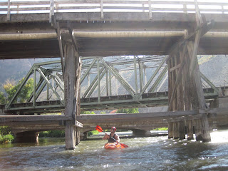
AMY'S NOTES: After hearing about the Mighty Weber for what seems like eons, I finally got to run it. It's a great narrow river that winds it's way through Ogden canyon. Stretches of calm interspersed with rock gardens, eddies that swirl in all directions, a very good surf wave, one really fun drop, and steel bridges that crisscross the river in multiple places. I took the bandit and Brook was in a hard shell. A beautiful warm Saturday afternoon with hits of fall foliage and very few people on the river.

Monday, September 14, 2009

AlBION BASIN: CECRET LAKE, GERMANIA RIDGE


WEATHER: Storms, rain, wind & cold

AMY'S NOTES: The second trip to Albion Basin this summer though a completely different landscape this time because of the weather and turning colors of the vegetation. Storm clouds, rain, a lot of wind, and a beautiful sunset. A short hike to Cecret Lake and then we carefully picked our way up and then down the ridge that is closest to the Germania lift. Despite my careful steps I managed to get scratched up (see pic). No week would be complete without a few good war wounds. A really beautiful time to be up Little Cottonwood Canyon. I believe summer is over and fall has arrived.

TOUR DE PARK CITY


WEATHER: Sunny summer day

AMY'S NOTES: A five hour bike tour of Park City backwood nostalgia hosted by a native. Copper kettle brewing, the Alamo, the historic Glenwood cemetery, Daly Canyon, Main St., abandoned mines, explosive vaults, Miss America 1950, long winding trails through grassy mountain meadows, and much more.

Thursday, September 10, 2009

TWIN PEAKS ATTEMPT #2


HIKERS: Amy, Dave, Justin, Terry, Andrew, Lucy
DATE: Sat, 9/5
WEATHER: 50 F at start, rain, overcast
RT TIME: 6 hours approx

AMY'S NOTES: Unbelievable. Thwarted again! Headed up the trail at 6 am at a fast pace making very good time. Rather than going to the left of the lake we took the trail to the right of the lake. (Note to self, take the left...) Lost the trail. Picked our way up a very steep scree and talus slope to the ridge. Almost taken out by a few 40 mile an hour boulders passing within 6 feet of me. All very exciting. Ran out of time, the bad weather moved in, and a recent knee injury/surgery began haunting one of the party. I believe the saying is third time's the charm.

Sunday, August 23, 2009

STEWART FALLS


HIKERS: Amy, Brook

AMY'S NOTES: A yearly tradition. Drive up to Sundance, buy a homemade sucker on a wooden stick at the general store, ride Ray's lift to the top, meander down to the falls crossing creeks and wading through meadows of grass and aspen along the way, and then fill up on fish tacos at the Foundry Grill. I've managed to do this most every summer for the last couple decades. The menu at the grill changes but the mountains and incredible views of Timp are constants. A lovely mellow stroll through the mountains in late summer.

Tuesday, August 18, 2009

MOUNT OLYMPUS SUMMIT


DATE: Saturday, June 20
HIKERS: Amy, Dave, Matt
START TIME: 7:00 am
ELEVATION GAIN: 4200'
SUMMIT: 9026'
SUMMIT TIME: 3 hours 10 min
RT TIME: 5 hours
DISTANCE RT: 7 miles
WEATHER: Cool, scattered showers

AMY'S NOTES: Mt Oly has been a long time goal of mine. It was the mountain that filled the view from every window in the house I grew up in and served as my primary reference point in the Salt Lake Valley. As long as I could see Mt Olympus I always knew where home was. It was great to hike this with 2 guys that grew up next door.

The climb itself is straight up and pretty much a grind - think stair stepping. The top section involves some scrambling and jumping. At the summit there are spectacular views of Salt Lake to the east and all the rest of the Wasatch to the west. The weather conditions were great for keeping us cool but also made for very slippery rocks on the way down.

DIRECTIONS: The trailhead is roughly 1/4 mile north of Tolcate Hills Road along Wasatch Blvd at 5800 south on the east side of Wasatch Blvd., and is marked with a brown sign reading "Mount Olympus Trailhead". Park either along Wasatch Blvd. or in a slightly hidden parking lot just north of the trailhead.

Monday, August 17, 2009

TWIN PEAKS ATTEMPT

HIKERS: Amy, Dave, Justin
WEATHER: 53 F, Stormy - hail rain & thunder
ELEVATIONS:
SUMMIT: 11330'
DISTANCE RT:
RT TIME: 1 hour 45 min

AMY'S NOTES: Thwarted by stormy weather! A gorgeous hike cut short by hail, thunder, lightning, and other misc weather phenomenon. We hiked up an hour and reached the first meadow before deciding that this was not the day for a summit. Spotted a couple of rough grouse, watched low heavy clouds roll by, and to sound a little cheesy - generally marveled at the beauty around us.

DIRECTIONS: Big Cottonwood Canyon to the Mill B trailhead. From the bottom of the parking lot take the Broad Forks trail.

Sunday, August 9, 2009

MOUNT NEBO


HIKE: North Route to Mt. Nebo's highest peak
HIKERS: Amy, Dave, Matt
START: 8,100 ft., 8:40 am
SUMMIT: 11,928 ft., 3 hours 18 min
ELEV. GAIN: 3,828 ft.
RT TIME: 6 hours
RT DISTANCE: 8.84 miles
WEATHER: 45 F at start, mix of sun & overcast, cool

AMY'S NOTES: Nebo is still one of my favorites. This was a first summit for Dave and Matt. A cold front moved in over northern Utah this weekend and the weather could not have been more perfect for a Nebo summit in August. Temperatures were in the 50's at midday and when we reached the summit alone we watched our breath while clouds rolled in over us. A short stay on top (approx 10 min) and we headed down. There was some concern about thunderstorms. We spent a total of about 30 min sitting around - so you could shave about 30 min off the hike if you were in a hurry. A great way to spend a saturday.

TRAIL: Start at the Monument trailhead off of the Nebo Scenic Loop Rd and follow the dirt road to the right from the parking lot. The trail begins at the end of the road, follow the fence line up onto the Nebo Bench Trail. The trail is very clear until you are close to the summit at which point just pick your way along the ridge line through the shale.

For photos of last year's hike to nebo see: http://hazardstats.blogspot.com/2008/10/nebo-photos.html

Wednesday, August 5, 2009

ONEIDA NARROWS: BEAR RIVER, ID


AMY'S NOTES: Spent Saturday and Sunday running the Oneida with Virg and friends. Took both a hardshell and the new bandit. A fun Class I float above Redpoint Campground and a mellow Class II section below the campground with a couple of rock gardens to play in. About a 4.5 hour drive from home. Reminder to head up during the week to avoid the crowds and road dust.

Friday, July 31, 2009

DUSTY BERG TRAIL


HIKERS: Kim, Amy, Charlynn, Sandra, dogs (3)
TIME: Summit 25 min.
WEATHER: sunny, clear and cool- about 57F

KIM'S NOTES: This is the first ascent for us on this hike. It is a beautiful, but steep one. The Ponderosa pines through the lower section were my personal favorite. It is quite a narrow, hazardous trail. Loose dirt and gravel combined with the incline, plus tripping over all the dogs, it is amazing we didn't have more falls (yes, of course I fell).

Wednesday, July 22, 2009

BACKBONE


HIKERS: Jamie, Kim, Amy & dogs
SUMMIT TIME: 40 min to the gate
RT TIME: 1 hr 15 min (approx)
WEATHER: 77 F at finish

AMY'S NOTES: A lovely hike in Sanpete. A traverse through multiple ecological zones, small hamlets, and a stunning view of our latest public art water sculpture. Truly an inspiring place to live.

Tuesday, July 21, 2009

PROVO RIVER: LOWER TOWN SECTION


DATE: Monday, June 22, 2009
PADDLERS: Kim, Amy, Virg, Mark & Son
PUT-IN: Fire Station, Columbia Ln
TAKE-OUT: Utah Lake State Park
TIME: 2 hr (approx)
DISTANCE:
FLOW:

AMY'S NOTES: This section of the Provo really should be called the bushwack-swift-river-jungle-slalom run. This was the christening run for my new inflatable kayak. Unsure of how wet I would be getting, I opted not to take the camera so there are no pix of the river. But the first section was defined by a swift current moving through a winding landscape with several low bridges and branches for ducking, followed by a slow wide almost swampy section reminiscent of deep south places I've only seen in the movies.

SKYLINE MEANDER


HIKERS: Amy, Joane, Devyn, Bella, Sophie, the dogs
WEATHER: 72 F, Sunny

AMY'S NOTES: On top of skyline drive, east of ephraim in the mountains. Little Sophie and Bella weren't too psyched to be in the great outdoors, but Devyn loved it. As did the dogs and joane. It was about 15 degrees cooler and all the flowers were in bloom. Everything smelled great.

ALBION BASIN: LAKE CATHERINE


DATE: July 19, 2009
HIKERS: Amy & Lin
WEATHER: Sunny, 75 F
DISTANCE: 2.6 miles
SUMMIT TIME: 35 MIN
RT TIME: 1 H 55 MIN
SUMMIT ELEV: 10,000 ft (approx)

AMY'S NOTES: From Alta head up to the Sunnyside chairlift parking lot and take the Catherine Pass trail. A beautiful summer day filled with wildflowers, cool mountain water, pines, and a great escape from the heat in the valley.

Saturday, July 11, 2009

BALD MOUNTAIN


HIKERS: Amy, Isa & Hope the dogs
SUMMIT: 20 min 40 sec
RT TIME: 42 min
WEATHER: 63 F, overcast

AMY'S NOTES: Fastest time yet! Ran the last stretch tripping with Hope biting my ankles the whole way. The goal of under 20 minutes is not far away...